


Key Insights
The 4D GIS software market is projected for significant growth, expected to reach $14.5 billion by 2025, with a Compound Annual Growth Rate (CAGR) of 12.4% from 2025 to 2033. This expansion is driven by the increasing demand for advanced spatial analysis integrating temporal data. Key factors include the need for sophisticated environmental monitoring, climate change impact assessment, natural resource management, and disaster response. Urban planning benefits from 4D GIS for smarter city development, infrastructure optimization, and improved citizen services through time-based visualization. Evolving traffic monitoring systems, moving towards predictive analysis, also contribute to market expansion.
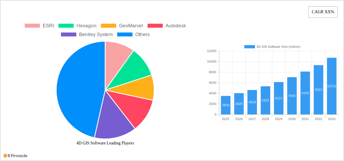
4D GIS Software Market Size (In Billion)

Advancements in sensor technology and remote sensing further enhance data collection for 4D GIS. While evolving data processing and AI integration present potential disruptions, challenges like data integration complexity and the need for specialized expertise are being mitigated by user-friendly interfaces and training. Applications span critical military operations, environmental protection, and urban development, highlighting the essential nature of 4D GIS. The market features competitive innovation from leaders such as ESRI and Hexagon, ensuring the accessibility of these spatial intelligence tools across industries.
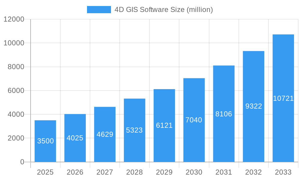
4D GIS Software Company Market Share
This report offers a comprehensive analysis of the global 4D GIS software market, covering its structure, dynamics, and future trajectory from 2025 to 2033. It provides insights into market concentration, innovation trends, regulatory environments, product substitutes, end-user demographics, and strategic initiatives. With an estimated market size of $14.5 billion, this report delivers actionable intelligence on growth drivers, technological advancements, competitive strategies, and regional market leadership.
4D GIS Software Market Structure & Innovation Trends
The 4D GIS software market is characterized by a moderately concentrated structure, with leading players like ESRI, Hexagon, and Autodesk holding significant market share. Innovation is primarily driven by advancements in real-time data integration, AI-powered analytics, and the increasing demand for predictive modeling capabilities. Regulatory frameworks are evolving to accommodate the sophisticated data management requirements of 4D GIS, particularly in urban planning and environmental monitoring. The emergence of sophisticated product substitutes, such as advanced BIM (Building Information Modeling) solutions with temporal capabilities, poses a competitive challenge. End-user demographics are expanding beyond traditional geospatial professionals to include urban planners, environmental scientists, infrastructure managers, and military strategists, all seeking enhanced temporal and spatial insights. Mergers and acquisitions are a significant trend, with deal values reaching millions, as companies strategically consolidate their offerings and expand their technological portfolios. For instance, recent M&A activities have focused on integrating sensor data processing and real-time visualization platforms.
- Market Concentration: Moderately concentrated, with top players holding a substantial market share exceeding fifty million.
- Innovation Drivers: Real-time data integration, AI/ML in analytics, predictive modeling, enhanced visualization.
- Regulatory Frameworks: Evolving standards for data privacy, interoperability, and real-time data streams.
- Product Substitutes: Advanced BIM solutions, specialized simulation software.
- End-User Demographics: Diversifying from geospatial experts to urban planners, environmental scientists, military analysts.
- M&A Activities: Active consolidation, with individual deal values in the tens of millions, bolstering comprehensive solution offerings.
4D GIS Software Market Dynamics & Trends
The 4D GIS software market is poised for robust growth, driven by an escalating need for dynamic and temporal spatial analysis across various sectors. The compound annual growth rate (CAGR) is projected to be in the double-digit percentage range, indicating significant market expansion. Technological disruptions, including the proliferation of IoT sensors, drone-based data acquisition, and cloud computing, are fundamental to this growth. These technologies enable the continuous capture and analysis of data across time, transforming static 2D and 3D maps into dynamic, interactive 4D environments. Consumer preferences are shifting towards intuitive user interfaces, advanced analytical tools that provide actionable insights, and seamless integration with existing enterprise systems. The competitive landscape is intensifying, with established players investing heavily in R&D to maintain their edge and newer entrants leveraging niche technologies and specialized applications. Market penetration is steadily increasing as organizations recognize the tangible benefits of 4D GIS in optimizing operations, mitigating risks, and enabling informed decision-making. The integration of machine learning algorithms for predictive maintenance and anomaly detection in infrastructure and environmental systems is a key trend. Furthermore, the development of digital twins, powered by 4D GIS data, is revolutionizing urban planning and infrastructure management, offering unprecedented simulation and scenario planning capabilities. The demand for real-time monitoring and response in disaster management and defense applications is also a significant growth catalyst. The increasing adoption of 4D GIS in smart city initiatives, focusing on optimizing traffic flow, energy consumption, and public safety, further underscores its growing importance.
Dominant Regions & Segments in 4D GIS Software
North America, particularly the United States, currently dominates the 4D GIS software market, driven by substantial government investment in defense and infrastructure, a strong technological ecosystem, and early adoption of advanced geospatial technologies. Countries within this region are at the forefront of developing and implementing sophisticated 4D GIS solutions for environmental monitoring, urban planning, and critical infrastructure management.
Application Dominance:
- Environmental Monitoring: This segment is a key driver of 4D GIS adoption due to the critical need for tracking changes over time, such as climate impact, pollution levels, and natural resource depletion. The ability to visualize and analyze temporal data streams from remote sensing and sensor networks is paramount for effective environmental stewardship. Countries with robust environmental regulations and a proactive approach to climate change are leading this segment.
- Urban Planning: The transformation of cities into smart, sustainable, and resilient environments relies heavily on 4D GIS. It enables planners to simulate the impact of new developments, analyze traffic flow dynamics, optimize public transportation routes, and manage infrastructure growth over time. Economic policies promoting urban development and infrastructure upgrades significantly bolster this segment.
- Traffic Monitoring: Real-time traffic analysis and predictive modeling are crucial for reducing congestion, improving safety, and optimizing logistics. 4D GIS provides the framework for integrating real-time traffic data from sensors, cameras, and GPS devices to create dynamic traffic models.
- Military: In defense applications, 4D GIS is vital for situational awareness, mission planning, and battlefield visualization. The ability to track troop movements, analyze terrain changes, and simulate operational scenarios in four dimensions offers a significant strategic advantage. Government defense spending is a primary economic policy driver.
- Others: This broad category includes applications in disaster management, agriculture, utilities, and construction, where temporal analysis of spatial data is increasingly valuable.
Type Dominance:
- Remote Sensing 4D GIS: This type of 4D GIS leverages data from satellites, aerial imagery, and LiDAR to capture historical and current environmental conditions and changes over time. Its dominance is fueled by the increasing availability of high-resolution satellite imagery and advanced processing techniques that can generate temporal datasets for large-scale analysis.
- Sensor-based 4D GIS: This segment focuses on integrating data from a vast network of ground-based and IoT sensors to provide real-time, dynamic insights into infrastructure, environment, and urban activities. The rapid expansion of the IoT ecosystem is a key driver of its growth and increasing dominance.
4D GIS Software Product Innovations
Recent product innovations in 4D GIS software are centered on enhanced real-time data integration, advanced AI-driven analytics for predictive modeling, and improved visualization capabilities for complex temporal datasets. Companies are developing solutions that seamlessly merge historical, current, and projected data, enabling users to simulate future scenarios and make proactive decisions. Key advancements include the integration of digital twin technologies, offering highly detailed virtual replicas of physical assets that can be monitored and analyzed in a temporal context. These innovations provide significant competitive advantages by offering more comprehensive insights, streamlining workflows, and enabling sophisticated scenario planning for applications ranging from urban development to environmental resilience.
Report Scope & Segmentation Analysis
This report encompasses a comprehensive analysis of the 4D GIS software market segmented by Application and Type.
Application Segments:
- Environmental Monitoring: Projected market size in the billions with a significant CAGR driven by climate change concerns and regulatory mandates.
- Urban Planning: Expected to witness substantial growth in the billions, fueled by smart city initiatives and infrastructure development.
- Traffic Monitoring: Market size in the hundreds of millions, experiencing steady growth due to the need for optimized transportation networks.
- Military: Significant market share in the billions, driven by defense spending and evolving strategic requirements.
- Others: A growing segment with a market size in the hundreds of millions, encompassing diverse applications.
Type Segments:
- Remote Sensing 4D GIS: A dominant segment with a market size in the billions, fueled by advanced satellite and aerial imaging technologies.
- Sensor-based 4D GIS: Experiencing rapid growth and projected to reach market sizes in the billions, driven by the proliferation of IoT devices and real-time data streams.
Key Drivers of 4D GIS Software Growth
The 4D GIS software market's growth is propelled by a confluence of technological, economic, and regulatory factors. The escalating adoption of IoT devices and sensors generates vast amounts of real-time spatial data, which 4D GIS can effectively analyze and visualize. Furthermore, the increasing need for predictive analytics in areas like disaster management, infrastructure maintenance, and urban development necessitates sophisticated temporal analysis capabilities. Government initiatives promoting smart cities, sustainable development, and defense modernization are significant economic drivers, fostering investment in advanced geospatial solutions. Regulatory frameworks that emphasize environmental monitoring and urban resilience are also creating a strong demand for 4D GIS capabilities.
Challenges in the 4D GIS Software Sector
Despite its promising growth, the 4D GIS software sector faces several challenges. The complexity of integrating and processing massive, multi-temporal datasets from disparate sources can be a significant technical hurdle. High implementation costs and the need for specialized expertise to operate and interpret 4D GIS data can deter adoption, particularly among smaller organizations. Data privacy and security concerns surrounding the collection and analysis of real-time spatial information also present regulatory and ethical challenges. Moreover, the continuous evolution of technology necessitates ongoing investment in software updates and training, creating a sustained financial burden for users. Competitive pressures from emerging technologies and alternative data analysis platforms also require continuous innovation and adaptation.
Emerging Opportunities in 4D GIS Software
Emerging opportunities in the 4D GIS software market are abundant, driven by advancements in AI, machine learning, and the expansion of the digital twin ecosystem. The increasing demand for predictive maintenance solutions in infrastructure and utilities offers a substantial growth avenue. The development of sophisticated climate modeling and adaptation tools powered by 4D GIS presents significant opportunities for environmental applications. Furthermore, the growing adoption of 4D GIS in virtual and augmented reality experiences for immersive data visualization is opening new markets. The potential for integrating 4D GIS with blockchain technology for secure and transparent data management is another exciting frontier.
Leading Players in the 4D GIS Software Market
- ESRI
- Hexagon
- GeoMarvel
- Autodesk
- Bentley Systems
- Trimble Inc.
- 4D Mapper
Key Developments in 4D GIS Software Industry
- 2023 October: ESRI launches a new suite of tools for real-time 4D data analysis and visualization, enhancing urban planning capabilities.
- 2023 May: Hexagon announces a strategic partnership with a leading IoT provider to integrate sensor data streams for enhanced infrastructure monitoring.
- 2022 December: Autodesk releases an advanced BIM integration for its 4D GIS platform, improving construction project management.
- 2022 September: GeoMarvel introduces AI-powered predictive analytics for environmental change detection.
- 2021 November: Trimble Inc. showcases its enhanced surveying and mapping technologies for 4D GIS data acquisition at a major industry conference.
- 2021 July: Bentley Systems acquires a company specializing in simulation software, bolstering its 4D GIS offerings for infrastructure design.
- 2020 October: 4D Mapper unveils a cloud-based platform for collaborative 4D geospatial data analysis, targeting the defense sector.
Future Outlook for 4D GIS Software Market
The future outlook for the 4D GIS software market is exceptionally bright, driven by an insatiable demand for dynamic, temporal spatial intelligence. The continued advancement of AI and machine learning will unlock deeper predictive capabilities, enabling proactive decision-making across all sectors. The widespread adoption of digital twins, powered by 4D GIS, will revolutionize urban development, infrastructure management, and industrial operations. Increased sensor deployment and the proliferation of IoT devices will provide a continuous stream of real-time data, making 4D GIS an indispensable tool for real-time situational awareness and operational optimization. Strategic collaborations and consolidations will continue to shape the market, leading to more comprehensive and integrated solutions that address complex global challenges. The market is projected to experience significant growth, with innovations focusing on user-friendly interfaces, enhanced interoperability, and robust security features.
4D GIS Software Segmentation
-
1. Application
- 1.1. Environmental Monitoring
- 1.2. Urban Planning
- 1.3. Traffic Monitoring
- 1.4. Military
- 1.5. Others
-
2. Types
- 2.1. Remote Sensing 4D GIS
- 2.2. Sensor-based 4D GIS
4D GIS Software Segmentation By Geography
-
1. North America
- 1.1. United States
- 1.2. Canada
- 1.3. Mexico
-
2. South America
- 2.1. Brazil
- 2.2. Argentina
- 2.3. Rest of South America
-
3. Europe
- 3.1. United Kingdom
- 3.2. Germany
- 3.3. France
- 3.4. Italy
- 3.5. Spain
- 3.6. Russia
- 3.7. Benelux
- 3.8. Nordics
- 3.9. Rest of Europe
-
4. Middle East & Africa
- 4.1. Turkey
- 4.2. Israel
- 4.3. GCC
- 4.4. North Africa
- 4.5. South Africa
- 4.6. Rest of Middle East & Africa
-
5. Asia Pacific
- 5.1. China
- 5.2. India
- 5.3. Japan
- 5.4. South Korea
- 5.5. ASEAN
- 5.6. Oceania
- 5.7. Rest of Asia Pacific
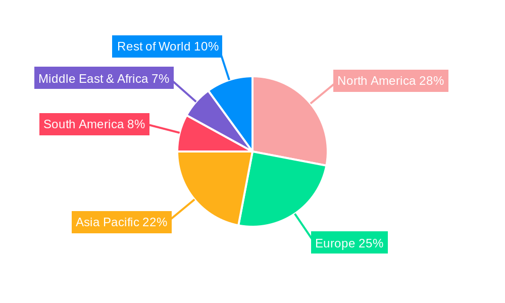
4D GIS Software Regional Market Share
Geographic Coverage of 4D GIS Software
4D GIS Software REPORT HIGHLIGHTS
| Aspects | Details |
|---|---|
| Study Period | 2020-2034 |
| Base Year | 2025 |
| Estimated Year | 2026 |
| Forecast Period | 2026-2034 |
| Historical Period | 2020-2025 |
| Growth Rate | CAGR of 12.4% from 2020-2034 |
| Segmentation |
|
Table of Contents
- 1. Introduction
- 1.1. Research Scope
- 1.2. Market Segmentation
- 1.3. Research Objective
- 1.4. Definitions and Assumptions
- 2. Executive Summary
- 2.1. Market Snapshot
- 3. Market Dynamics
- 3.1. Market Drivers
- 3.2. Market Restrains
- 3.3. Market Trends
- 3.4. Market Opportunities
- 4. Market Factor Analysis
- 4.1. Porters Five Forces
- 4.1.1. Bargaining Power of Suppliers
- 4.1.2. Bargaining Power of Buyers
- 4.1.3. Threat of New Entrants
- 4.1.4. Threat of Substitutes
- 4.1.5. Competitive Rivalry
- 4.2. PESTEL analysis
- 4.3. BCG Analysis
- 4.3.1. Stars (High Growth, High Market Share)
- 4.3.2. Cash Cows (Low Growth, High Market Share)
- 4.3.3. Question Mark (High Growth, Low Market Share)
- 4.3.4. Dogs (Low Growth, Low Market Share)
- 4.4. Ansoff Matrix Analysis
- 4.5. Supply Chain Analysis
- 4.6. Regulatory Landscape
- 4.7. Current Market Potential and Opportunity Assessment (TAM–SAM–SOM Framework)
- 4.8. PRI Analyst Note
- 4.1. Porters Five Forces
- 5. Market Analysis, Insights and Forecast 2021-2033
- 5.1. Market Analysis, Insights and Forecast - by Application
- 5.1.1. Environmental Monitoring
- 5.1.2. Urban Planning
- 5.1.3. Traffic Monitoring
- 5.1.4. Military
- 5.1.5. Others
- 5.2. Market Analysis, Insights and Forecast - by Types
- 5.2.1. Remote Sensing 4D GIS
- 5.2.2. Sensor-based 4D GIS
- 5.3. Market Analysis, Insights and Forecast - by Region
- 5.3.1. North America
- 5.3.2. South America
- 5.3.3. Europe
- 5.3.4. Middle East & Africa
- 5.3.5. Asia Pacific
- 5.1. Market Analysis, Insights and Forecast - by Application
- 6. Global 4D GIS Software Analysis, Insights and Forecast, 2021-2033
- 6.1. Market Analysis, Insights and Forecast - by Application
- 6.1.1. Environmental Monitoring
- 6.1.2. Urban Planning
- 6.1.3. Traffic Monitoring
- 6.1.4. Military
- 6.1.5. Others
- 6.2. Market Analysis, Insights and Forecast - by Types
- 6.2.1. Remote Sensing 4D GIS
- 6.2.2. Sensor-based 4D GIS
- 6.1. Market Analysis, Insights and Forecast - by Application
- 7. North America 4D GIS Software Analysis, Insights and Forecast, 2020-2032
- 7.1. Market Analysis, Insights and Forecast - by Application
- 7.1.1. Environmental Monitoring
- 7.1.2. Urban Planning
- 7.1.3. Traffic Monitoring
- 7.1.4. Military
- 7.1.5. Others
- 7.2. Market Analysis, Insights and Forecast - by Types
- 7.2.1. Remote Sensing 4D GIS
- 7.2.2. Sensor-based 4D GIS
- 7.1. Market Analysis, Insights and Forecast - by Application
- 8. South America 4D GIS Software Analysis, Insights and Forecast, 2020-2032
- 8.1. Market Analysis, Insights and Forecast - by Application
- 8.1.1. Environmental Monitoring
- 8.1.2. Urban Planning
- 8.1.3. Traffic Monitoring
- 8.1.4. Military
- 8.1.5. Others
- 8.2. Market Analysis, Insights and Forecast - by Types
- 8.2.1. Remote Sensing 4D GIS
- 8.2.2. Sensor-based 4D GIS
- 8.1. Market Analysis, Insights and Forecast - by Application
- 9. Europe 4D GIS Software Analysis, Insights and Forecast, 2020-2032
- 9.1. Market Analysis, Insights and Forecast - by Application
- 9.1.1. Environmental Monitoring
- 9.1.2. Urban Planning
- 9.1.3. Traffic Monitoring
- 9.1.4. Military
- 9.1.5. Others
- 9.2. Market Analysis, Insights and Forecast - by Types
- 9.2.1. Remote Sensing 4D GIS
- 9.2.2. Sensor-based 4D GIS
- 9.1. Market Analysis, Insights and Forecast - by Application
- 10. Middle East & Africa 4D GIS Software Analysis, Insights and Forecast, 2020-2032
- 10.1. Market Analysis, Insights and Forecast - by Application
- 10.1.1. Environmental Monitoring
- 10.1.2. Urban Planning
- 10.1.3. Traffic Monitoring
- 10.1.4. Military
- 10.1.5. Others
- 10.2. Market Analysis, Insights and Forecast - by Types
- 10.2.1. Remote Sensing 4D GIS
- 10.2.2. Sensor-based 4D GIS
- 10.1. Market Analysis, Insights and Forecast - by Application
- 11. Asia Pacific 4D GIS Software Analysis, Insights and Forecast, 2020-2032
- 11.1. Market Analysis, Insights and Forecast - by Application
- 11.1.1. Environmental Monitoring
- 11.1.2. Urban Planning
- 11.1.3. Traffic Monitoring
- 11.1.4. Military
- 11.1.5. Others
- 11.2. Market Analysis, Insights and Forecast - by Types
- 11.2.1. Remote Sensing 4D GIS
- 11.2.2. Sensor-based 4D GIS
- 11.1. Market Analysis, Insights and Forecast - by Application
- 12. Competitive Analysis
- 12.1. Company Profiles
- 12.1.1 ESRI
- 12.1.1.1. Company Overview
- 12.1.1.2. Products
- 12.1.1.3. Company Financials
- 12.1.1.4. SWOT Analysis
- 12.1.2 Hexagon
- 12.1.2.1. Company Overview
- 12.1.2.2. Products
- 12.1.2.3. Company Financials
- 12.1.2.4. SWOT Analysis
- 12.1.3 GeoMarvel
- 12.1.3.1. Company Overview
- 12.1.3.2. Products
- 12.1.3.3. Company Financials
- 12.1.3.4. SWOT Analysis
- 12.1.4 Autodesk
- 12.1.4.1. Company Overview
- 12.1.4.2. Products
- 12.1.4.3. Company Financials
- 12.1.4.4. SWOT Analysis
- 12.1.5 Bentley System
- 12.1.5.1. Company Overview
- 12.1.5.2. Products
- 12.1.5.3. Company Financials
- 12.1.5.4. SWOT Analysis
- 12.1.6 Trimble Inc.
- 12.1.6.1. Company Overview
- 12.1.6.2. Products
- 12.1.6.3. Company Financials
- 12.1.6.4. SWOT Analysis
- 12.1.7 4D Mapper
- 12.1.7.1. Company Overview
- 12.1.7.2. Products
- 12.1.7.3. Company Financials
- 12.1.7.4. SWOT Analysis
- 12.1.1 ESRI
- 12.2. Market Entropy
- 12.2.1 Company's Key Areas Served
- 12.2.2 Recent Developments
- 12.3. Company Market Share Analysis 2025
- 12.3.1 Top 5 Companies Market Share Analysis
- 12.3.2 Top 3 Companies Market Share Analysis
- 12.4. List of Potential Customers
- 13. Research Methodology
List of Figures
- Figure 1: Global 4D GIS Software Revenue Breakdown (billion, %) by Region 2025 & 2033
- Figure 2: North America 4D GIS Software Revenue (billion), by Application 2025 & 2033
- Figure 3: North America 4D GIS Software Revenue Share (%), by Application 2025 & 2033
- Figure 4: North America 4D GIS Software Revenue (billion), by Types 2025 & 2033
- Figure 5: North America 4D GIS Software Revenue Share (%), by Types 2025 & 2033
- Figure 6: North America 4D GIS Software Revenue (billion), by Country 2025 & 2033
- Figure 7: North America 4D GIS Software Revenue Share (%), by Country 2025 & 2033
- Figure 8: South America 4D GIS Software Revenue (billion), by Application 2025 & 2033
- Figure 9: South America 4D GIS Software Revenue Share (%), by Application 2025 & 2033
- Figure 10: South America 4D GIS Software Revenue (billion), by Types 2025 & 2033
- Figure 11: South America 4D GIS Software Revenue Share (%), by Types 2025 & 2033
- Figure 12: South America 4D GIS Software Revenue (billion), by Country 2025 & 2033
- Figure 13: South America 4D GIS Software Revenue Share (%), by Country 2025 & 2033
- Figure 14: Europe 4D GIS Software Revenue (billion), by Application 2025 & 2033
- Figure 15: Europe 4D GIS Software Revenue Share (%), by Application 2025 & 2033
- Figure 16: Europe 4D GIS Software Revenue (billion), by Types 2025 & 2033
- Figure 17: Europe 4D GIS Software Revenue Share (%), by Types 2025 & 2033
- Figure 18: Europe 4D GIS Software Revenue (billion), by Country 2025 & 2033
- Figure 19: Europe 4D GIS Software Revenue Share (%), by Country 2025 & 2033
- Figure 20: Middle East & Africa 4D GIS Software Revenue (billion), by Application 2025 & 2033
- Figure 21: Middle East & Africa 4D GIS Software Revenue Share (%), by Application 2025 & 2033
- Figure 22: Middle East & Africa 4D GIS Software Revenue (billion), by Types 2025 & 2033
- Figure 23: Middle East & Africa 4D GIS Software Revenue Share (%), by Types 2025 & 2033
- Figure 24: Middle East & Africa 4D GIS Software Revenue (billion), by Country 2025 & 2033
- Figure 25: Middle East & Africa 4D GIS Software Revenue Share (%), by Country 2025 & 2033
- Figure 26: Asia Pacific 4D GIS Software Revenue (billion), by Application 2025 & 2033
- Figure 27: Asia Pacific 4D GIS Software Revenue Share (%), by Application 2025 & 2033
- Figure 28: Asia Pacific 4D GIS Software Revenue (billion), by Types 2025 & 2033
- Figure 29: Asia Pacific 4D GIS Software Revenue Share (%), by Types 2025 & 2033
- Figure 30: Asia Pacific 4D GIS Software Revenue (billion), by Country 2025 & 2033
- Figure 31: Asia Pacific 4D GIS Software Revenue Share (%), by Country 2025 & 2033
List of Tables
- Table 1: Global 4D GIS Software Revenue billion Forecast, by Application 2020 & 2033
- Table 2: Global 4D GIS Software Revenue billion Forecast, by Types 2020 & 2033
- Table 3: Global 4D GIS Software Revenue billion Forecast, by Region 2020 & 2033
- Table 4: Global 4D GIS Software Revenue billion Forecast, by Application 2020 & 2033
- Table 5: Global 4D GIS Software Revenue billion Forecast, by Types 2020 & 2033
- Table 6: Global 4D GIS Software Revenue billion Forecast, by Country 2020 & 2033
- Table 7: United States 4D GIS Software Revenue (billion) Forecast, by Application 2020 & 2033
- Table 8: Canada 4D GIS Software Revenue (billion) Forecast, by Application 2020 & 2033
- Table 9: Mexico 4D GIS Software Revenue (billion) Forecast, by Application 2020 & 2033
- Table 10: Global 4D GIS Software Revenue billion Forecast, by Application 2020 & 2033
- Table 11: Global 4D GIS Software Revenue billion Forecast, by Types 2020 & 2033
- Table 12: Global 4D GIS Software Revenue billion Forecast, by Country 2020 & 2033
- Table 13: Brazil 4D GIS Software Revenue (billion) Forecast, by Application 2020 & 2033
- Table 14: Argentina 4D GIS Software Revenue (billion) Forecast, by Application 2020 & 2033
- Table 15: Rest of South America 4D GIS Software Revenue (billion) Forecast, by Application 2020 & 2033
- Table 16: Global 4D GIS Software Revenue billion Forecast, by Application 2020 & 2033
- Table 17: Global 4D GIS Software Revenue billion Forecast, by Types 2020 & 2033
- Table 18: Global 4D GIS Software Revenue billion Forecast, by Country 2020 & 2033
- Table 19: United Kingdom 4D GIS Software Revenue (billion) Forecast, by Application 2020 & 2033
- Table 20: Germany 4D GIS Software Revenue (billion) Forecast, by Application 2020 & 2033
- Table 21: France 4D GIS Software Revenue (billion) Forecast, by Application 2020 & 2033
- Table 22: Italy 4D GIS Software Revenue (billion) Forecast, by Application 2020 & 2033
- Table 23: Spain 4D GIS Software Revenue (billion) Forecast, by Application 2020 & 2033
- Table 24: Russia 4D GIS Software Revenue (billion) Forecast, by Application 2020 & 2033
- Table 25: Benelux 4D GIS Software Revenue (billion) Forecast, by Application 2020 & 2033
- Table 26: Nordics 4D GIS Software Revenue (billion) Forecast, by Application 2020 & 2033
- Table 27: Rest of Europe 4D GIS Software Revenue (billion) Forecast, by Application 2020 & 2033
- Table 28: Global 4D GIS Software Revenue billion Forecast, by Application 2020 & 2033
- Table 29: Global 4D GIS Software Revenue billion Forecast, by Types 2020 & 2033
- Table 30: Global 4D GIS Software Revenue billion Forecast, by Country 2020 & 2033
- Table 31: Turkey 4D GIS Software Revenue (billion) Forecast, by Application 2020 & 2033
- Table 32: Israel 4D GIS Software Revenue (billion) Forecast, by Application 2020 & 2033
- Table 33: GCC 4D GIS Software Revenue (billion) Forecast, by Application 2020 & 2033
- Table 34: North Africa 4D GIS Software Revenue (billion) Forecast, by Application 2020 & 2033
- Table 35: South Africa 4D GIS Software Revenue (billion) Forecast, by Application 2020 & 2033
- Table 36: Rest of Middle East & Africa 4D GIS Software Revenue (billion) Forecast, by Application 2020 & 2033
- Table 37: Global 4D GIS Software Revenue billion Forecast, by Application 2020 & 2033
- Table 38: Global 4D GIS Software Revenue billion Forecast, by Types 2020 & 2033
- Table 39: Global 4D GIS Software Revenue billion Forecast, by Country 2020 & 2033
- Table 40: China 4D GIS Software Revenue (billion) Forecast, by Application 2020 & 2033
- Table 41: India 4D GIS Software Revenue (billion) Forecast, by Application 2020 & 2033
- Table 42: Japan 4D GIS Software Revenue (billion) Forecast, by Application 2020 & 2033
- Table 43: South Korea 4D GIS Software Revenue (billion) Forecast, by Application 2020 & 2033
- Table 44: ASEAN 4D GIS Software Revenue (billion) Forecast, by Application 2020 & 2033
- Table 45: Oceania 4D GIS Software Revenue (billion) Forecast, by Application 2020 & 2033
- Table 46: Rest of Asia Pacific 4D GIS Software Revenue (billion) Forecast, by Application 2020 & 2033
Frequently Asked Questions
1. What is the projected Compound Annual Growth Rate (CAGR) of the 4D GIS Software?
The projected CAGR is approximately 12.4%.
2. Which companies are prominent players in the 4D GIS Software?
Key companies in the market include ESRI, Hexagon, GeoMarvel, Autodesk, Bentley System, Trimble Inc., 4D Mapper.
3. What are the main segments of the 4D GIS Software?
The market segments include Application, Types.
4. Can you provide details about the market size?
The market size is estimated to be USD 14.5 billion as of 2022.
5. What are some drivers contributing to market growth?
N/A
6. What are the notable trends driving market growth?
N/A
7. Are there any restraints impacting market growth?
N/A
8. Can you provide examples of recent developments in the market?
N/A
9. What pricing options are available for accessing the report?
Pricing options include single-user, multi-user, and enterprise licenses priced at USD 4900.00, USD 7350.00, and USD 9800.00 respectively.
10. Is the market size provided in terms of value or volume?
The market size is provided in terms of value, measured in billion.
11. Are there any specific market keywords associated with the report?
Yes, the market keyword associated with the report is "4D GIS Software," which aids in identifying and referencing the specific market segment covered.
12. How do I determine which pricing option suits my needs best?
The pricing options vary based on user requirements and access needs. Individual users may opt for single-user licenses, while businesses requiring broader access may choose multi-user or enterprise licenses for cost-effective access to the report.
13. Are there any additional resources or data provided in the 4D GIS Software report?
While the report offers comprehensive insights, it's advisable to review the specific contents or supplementary materials provided to ascertain if additional resources or data are available.
14. How can I stay updated on further developments or reports in the 4D GIS Software?
To stay informed about further developments, trends, and reports in the 4D GIS Software, consider subscribing to industry newsletters, following relevant companies and organizations, or regularly checking reputable industry news sources and publications.
Methodology
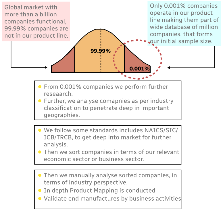
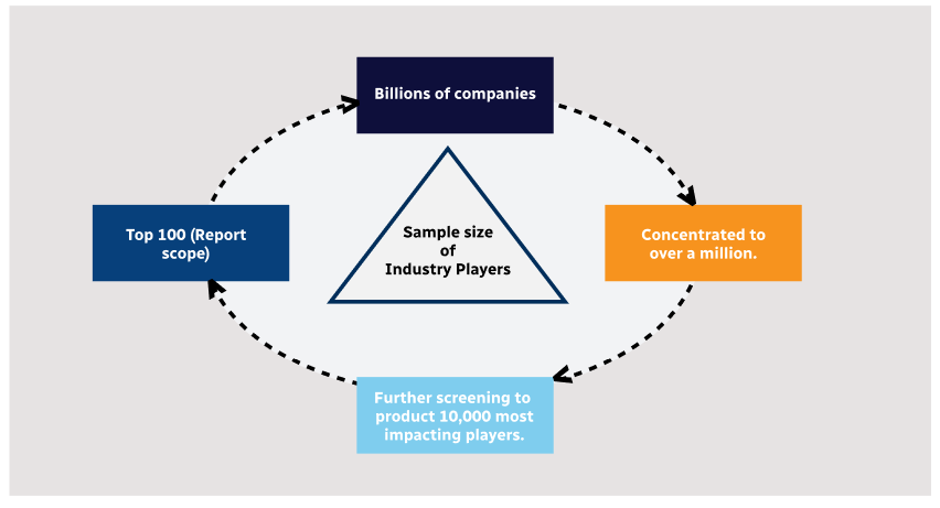
Step 1 - Identification of Relevant Samples Size from Population Database
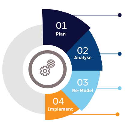
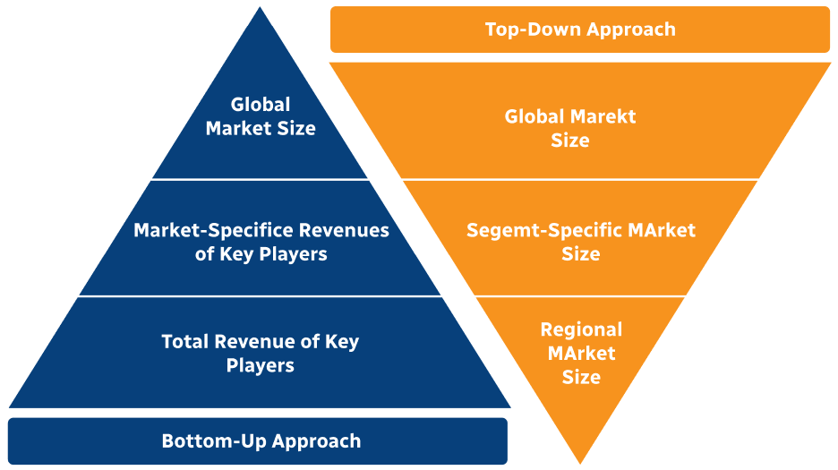
Step 2 - Approaches for Defining Global Market Size (Value, Volume* & Price*)
Note*: In applicable scenarios
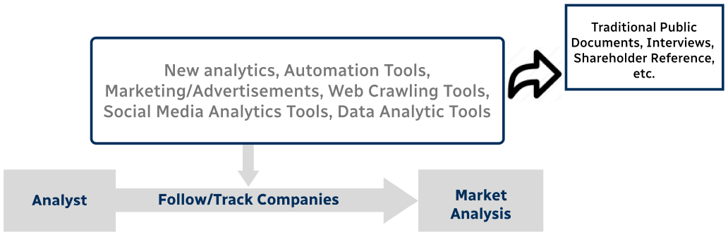
Step 3 - Data Sources
Primary Research
- Web Analytics
- Survey Reports
- Research Institute
- Latest Research Reports
- Opinion Leaders
Secondary Research
- Annual Reports
- White Paper
- Latest Press Release
- Industry Association
- Paid Database
- Investor Presentations
Step 4 - Data Triangulation
Involves using different sources of information in order to increase the validity of a study
These sources are likely to be stakeholders in a program - participants, other researchers, program staff, other community members, and so on.
Then we put all data in single framework & apply various statistical tools to find out the dynamic on the market.
During the analysis stage, feedback from the stakeholder groups would be compared to determine areas of agreement as well as areas of divergence