
Key Insights
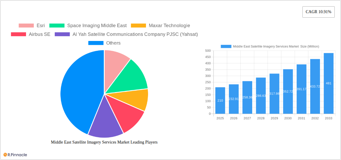
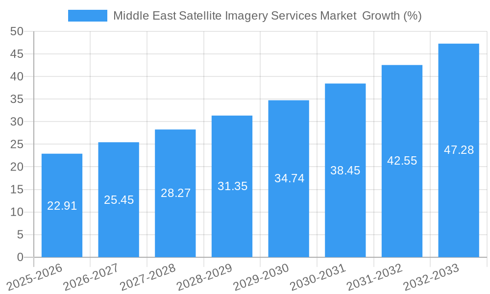
The Middle East Satellite Imagery Services market, valued at $210 million in 2025, is projected to experience robust growth, exhibiting a Compound Annual Growth Rate (CAGR) of 10.91% from 2025 to 2033. This expansion is driven by several key factors. Firstly, increasing government investments in infrastructure development, particularly in the UAE and Saudi Arabia, fuel demand for high-resolution imagery for urban planning, construction monitoring, and resource management. Secondly, the region's strategic geopolitical location and concerns about security necessitate advanced surveillance and intelligence capabilities, significantly boosting the adoption of satellite imagery solutions. Furthermore, the burgeoning agriculture and forestry sectors are leveraging satellite data for precision farming, crop monitoring, and deforestation tracking, contributing to market growth. The rising adoption of cloud-based platforms and advanced analytics tools further enhances efficiency and accessibility, making satellite imagery more readily available and affordable across various applications.
However, market growth may face certain challenges. Data privacy concerns and regulations surrounding the use of satellite imagery are likely to impose restraints. The high initial investment costs associated with acquiring and deploying satellite imagery technology could also hinder market penetration among smaller organizations. Competition among established players like Esri, Maxar Technologies, and Airbus SE is intense, putting pressure on pricing and requiring continuous innovation to maintain market share. Despite these challenges, the overall outlook for the Middle East Satellite Imagery Services market remains positive, driven by sustained government spending, increasing private sector adoption, and the continuous evolution of technology. The market's segmentation by application (Geospatial Data Acquisition and Mapping, Natural Resource Management etc.) and end-user (Government, Construction, etc.) highlights diverse opportunities for specialized service providers.
Middle East Satellite Imagery Services Market Report: 2019-2033
This comprehensive report provides an in-depth analysis of the Middle East Satellite Imagery Services Market, offering invaluable insights for industry professionals, investors, and strategic decision-makers. Covering the period from 2019 to 2033, with a focus on 2025, this report delivers a detailed understanding of market dynamics, growth drivers, challenges, and future opportunities. The market is segmented by application (Geospatial Data Acquisition and Mapping, Natural Resource Management, Surveillance and Security, Conservation and Research, Disaster Management, Intelligence) and end-user (Government, Construction, Transportation and Logistics, Military and Defense, Forestry and Agriculture, Other End-Users). Key players such as Esri, Space Imaging Middle East, Maxar Technologies, Airbus SE, and others are profiled, highlighting their strategies and market positions.
Middle East Satellite Imagery Services Market Structure & Innovation Trends
The Middle East Satellite Imagery Services Market exhibits a moderately concentrated structure, with a few major players holding significant market share. Esri, Maxar Technologies, and Airbus SE are among the leading companies, while regional players like Al Yah Satellite Communications Company PJSC (Yahsat) and others hold substantial market presence within their respective niches. The market is characterized by continuous innovation driven by advancements in satellite technology, including higher resolution sensors, improved data processing capabilities, and the integration of AI/ML for enhanced analytics. Regulatory frameworks vary across the region, impacting data access and usage. The market witnesses a steady stream of M&A activities, with deal values ranging from xx Million to xx Million in recent years, driven by the need for expansion, technological synergy, and accessing new markets. Product substitutes, like aerial photography, are available but lack the comprehensive coverage and frequency offered by satellite imagery. The end-user demographics are diverse, ranging from government agencies and military organizations to private sector companies in construction, agriculture, and other industries.
- Market Concentration: Moderately concentrated with a few dominant players.
- Innovation Drivers: Advancements in sensor technology, AI/ML integration, and data processing.
- Regulatory Landscape: Variable across the region, influencing data access.
- M&A Activity: Ongoing, with deal values ranging from xx Million to xx Million.
- Market Share: Esri, Maxar, and Airbus hold significant shares; regional players hold substantial niche market shares.
Middle East Satellite Imagery Services Market Dynamics & Trends
The Middle East Satellite Imagery Services Market is projected to experience robust growth, with a CAGR of xx% during the forecast period (2025-2033). Several factors are driving this expansion, including increasing government investments in infrastructure projects, growing demand for high-resolution imagery in various applications like urban planning and natural resource management, and rising adoption of advanced analytics for deriving actionable insights from geospatial data. Technological disruptions, like the advent of smallsat constellations and the integration of AI, are revolutionizing the sector, enabling faster data acquisition, processing, and analysis. Consumer preferences are shifting towards real-time data access, cloud-based solutions, and customized analytical services. Competitive dynamics are intense, with both established players and new entrants vying for market share through product differentiation, pricing strategies, and strategic partnerships. Market penetration is increasing, with wider adoption across various sectors.
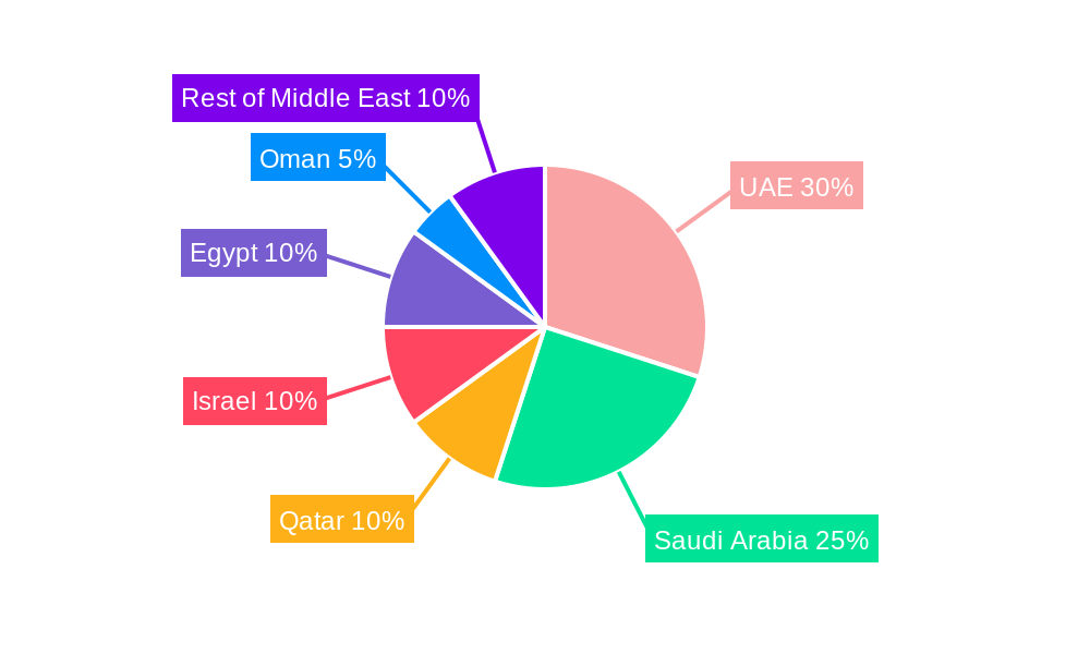
Dominant Regions & Segments in Middle East Satellite Imagery Services Market
The UAE and Saudi Arabia are the leading regions within the Middle East Satellite Imagery Services Market, driven by substantial investments in infrastructure development, smart city initiatives, and national security programs. The Government segment holds a significant share among end-users, particularly in the areas of surveillance and security. Within applications, Geospatial Data Acquisition and Mapping, Surveillance and Security, and Natural Resource Management are dominant segments.
- Key Drivers in the UAE and Saudi Arabia:
- High government spending on infrastructure projects: Driving demand for accurate mapping and monitoring.
- Focus on smart city development: Requires comprehensive geospatial data.
- National security concerns: Increased reliance on satellite imagery for intelligence gathering and border security.
- Dominant Application Segments:
- Geospatial Data Acquisition and Mapping: High demand for precise land surveying and urban planning.
- Surveillance and Security: Vital for monitoring borders, critical infrastructure, and public safety.
- Natural Resource Management: Essential for efficient water resource management, oil & gas exploration, and agriculture.
Middle East Satellite Imagery Services Market Product Innovations
Recent product innovations include higher resolution satellite imagery, advanced analytics platforms powered by AI and machine learning, and cloud-based solutions enabling efficient data access and processing. These advancements improve accuracy, speed up data analysis, and offer flexible deployment options, enhancing the market’s value proposition for various sectors. The market is witnessing the integration of IoT sensors with satellite imagery for comprehensive data capture and monitoring across diverse applications.
Report Scope & Segmentation Analysis
This report segments the Middle East Satellite Imagery Services Market by application (Geospatial Data Acquisition and Mapping, Natural Resource Management, Surveillance and Security, Conservation and Research, Disaster Management, Intelligence) and end-user (Government, Construction, Transportation and Logistics, Military and Defense, Forestry and Agriculture, Other End-Users). Each segment showcases unique growth projections and market sizes, influenced by specific industry trends and competitive dynamics. Market size estimates are provided for each segment for the historical period (2019-2024), base year (2025), and forecast period (2025-2033).
Key Drivers of Middle East Satellite Imagery Services Market Growth
The market’s growth is fueled by increasing government investments in infrastructure, rapid urbanization, the growing need for effective resource management, and a heightened focus on national security. The adoption of advanced technologies like AI and cloud computing further accelerates market expansion, improving data analysis efficiency and accessibility. Favorable government policies promoting the development of the geospatial industry also contribute to the growth trajectory.
Challenges in the Middle East Satellite Imagery Services Market Sector
Challenges include data privacy concerns, the need for skilled professionals in data interpretation and analysis, and the potential for high initial investment costs in satellite technology and infrastructure. The market also faces competition from alternative technologies and the need to address varying regulatory frameworks across different countries in the region. Supply chain disruptions can also impact project timelines and overall market stability. These constraints negatively impact the market growth rate by an estimated xx%.
Emerging Opportunities in Middle East Satellite Imagery Services Market
Emerging opportunities lie in the increasing demand for high-resolution imagery in various applications like precision agriculture, environmental monitoring, and disaster response. The integration of IoT sensors with satellite imagery and the potential for customized analytical services present promising avenues for market expansion. The development of innovative solutions tailored to specific needs across different sectors offers significant growth potential.
Leading Players in the Middle East Satellite Imagery Services Market Market
- Esri
- Space Imaging Middle East
- Maxar Technologies
- Airbus SE
- Al Yah Satellite Communications Company PJSC (Yahsat)
- Serco Group plc
- Thales Group
- GEOMAP Consultants
- SARsat Arabia
- Northstar Saudi Arabia
Key Developments in Middle East Satellite Imagery Services Market Industry
- July 2023: Impact Observatory partnered with Planet Labs PBC, leveraging AI analytics for enhanced land cover and land use assessment. This collaboration is expected to significantly improve the quality and availability of geospatial data.
- December 2022: SpaceX successfully deployed an Israeli Earth-imaging satellite developed by ImageSat International (ISI), primarily for military and intelligence applications. This marks a significant advancement in the regional space capabilities.
Future Outlook for Middle East Satellite Imagery Services Market Market
The Middle East Satellite Imagery Services Market is poised for significant growth in the coming years, driven by continuous technological innovation, increasing government investments, and expanding applications across various sectors. The strategic adoption of AI and cloud-based solutions will play a crucial role in shaping the future market landscape, creating new opportunities for growth and fostering wider adoption across a spectrum of industries.
Middle East Satellite Imagery Services Market Segmentation
-
1. Application
- 1.1. Geospatial Data Acquisition and Mapping
- 1.2. Natural Resource Management
- 1.3. Surveillance and Security
- 1.4. Conservation and Research
- 1.5. Disaster Management
- 1.6. Intelligence
-
2. End-User
- 2.1. Government
- 2.2. Construction
- 2.3. Transportation and Logistics
- 2.4. Military and Defense
- 2.5. Forestry and Agriculture
- 2.6. Other End-Users
-
3. Geography
- 3.1. UAE
- 3.2. Saudi Arabia
Middle East Satellite Imagery Services Market Segmentation By Geography
- 1. UAE
- 2. Saudi Arabia
Middle East Satellite Imagery Services Market REPORT HIGHLIGHTS
| Aspects | Details |
|---|---|
| Study Period | 2019-2033 |
| Base Year | 2024 |
| Estimated Year | 2025 |
| Forecast Period | 2025-2033 |
| Historical Period | 2019-2024 |
| Growth Rate | CAGR of 10.91% from 2019-2033 |
| Segmentation |
|
Table of Contents
- 1. Introduction
- 1.1. Research Scope
- 1.2. Market Segmentation
- 1.3. Research Methodology
- 1.4. Definitions and Assumptions
- 2. Executive Summary
- 2.1. Introduction
- 3. Market Dynamics
- 3.1. Introduction
- 3.2. Market Drivers
- 3.2.1. Increasing Adoption of Location-based Services; Surge in the usage of Satellite data
- 3.3. Market Restrains
- 3.3.1. High-resolution Images Offered by Other Imaging Technologies
- 3.4. Market Trends
- 3.4.1. Increasing Adoption of Location-based Services
- 4. Market Factor Analysis
- 4.1. Porters Five Forces
- 4.2. Supply/Value Chain
- 4.3. PESTEL analysis
- 4.4. Market Entropy
- 4.5. Patent/Trademark Analysis
- 5. Middle East Satellite Imagery Services Market Analysis, Insights and Forecast, 2019-2031
- 5.1. Market Analysis, Insights and Forecast - by Application
- 5.1.1. Geospatial Data Acquisition and Mapping
- 5.1.2. Natural Resource Management
- 5.1.3. Surveillance and Security
- 5.1.4. Conservation and Research
- 5.1.5. Disaster Management
- 5.1.6. Intelligence
- 5.2. Market Analysis, Insights and Forecast - by End-User
- 5.2.1. Government
- 5.2.2. Construction
- 5.2.3. Transportation and Logistics
- 5.2.4. Military and Defense
- 5.2.5. Forestry and Agriculture
- 5.2.6. Other End-Users
- 5.3. Market Analysis, Insights and Forecast - by Geography
- 5.3.1. UAE
- 5.3.2. Saudi Arabia
- 5.4. Market Analysis, Insights and Forecast - by Region
- 5.4.1. UAE
- 5.4.2. Saudi Arabia
- 5.1. Market Analysis, Insights and Forecast - by Application
- 6. UAE Middle East Satellite Imagery Services Market Analysis, Insights and Forecast, 2019-2031
- 6.1. Market Analysis, Insights and Forecast - by Application
- 6.1.1. Geospatial Data Acquisition and Mapping
- 6.1.2. Natural Resource Management
- 6.1.3. Surveillance and Security
- 6.1.4. Conservation and Research
- 6.1.5. Disaster Management
- 6.1.6. Intelligence
- 6.2. Market Analysis, Insights and Forecast - by End-User
- 6.2.1. Government
- 6.2.2. Construction
- 6.2.3. Transportation and Logistics
- 6.2.4. Military and Defense
- 6.2.5. Forestry and Agriculture
- 6.2.6. Other End-Users
- 6.3. Market Analysis, Insights and Forecast - by Geography
- 6.3.1. UAE
- 6.3.2. Saudi Arabia
- 6.1. Market Analysis, Insights and Forecast - by Application
- 7. Saudi Arabia Middle East Satellite Imagery Services Market Analysis, Insights and Forecast, 2019-2031
- 7.1. Market Analysis, Insights and Forecast - by Application
- 7.1.1. Geospatial Data Acquisition and Mapping
- 7.1.2. Natural Resource Management
- 7.1.3. Surveillance and Security
- 7.1.4. Conservation and Research
- 7.1.5. Disaster Management
- 7.1.6. Intelligence
- 7.2. Market Analysis, Insights and Forecast - by End-User
- 7.2.1. Government
- 7.2.2. Construction
- 7.2.3. Transportation and Logistics
- 7.2.4. Military and Defense
- 7.2.5. Forestry and Agriculture
- 7.2.6. Other End-Users
- 7.3. Market Analysis, Insights and Forecast - by Geography
- 7.3.1. UAE
- 7.3.2. Saudi Arabia
- 7.1. Market Analysis, Insights and Forecast - by Application
- 8. United Arab Emirates Middle East Satellite Imagery Services Market Analysis, Insights and Forecast, 2019-2031
- 9. Saudi Arabia Middle East Satellite Imagery Services Market Analysis, Insights and Forecast, 2019-2031
- 10. Qatar Middle East Satellite Imagery Services Market Analysis, Insights and Forecast, 2019-2031
- 11. Israel Middle East Satellite Imagery Services Market Analysis, Insights and Forecast, 2019-2031
- 12. Egypt Middle East Satellite Imagery Services Market Analysis, Insights and Forecast, 2019-2031
- 13. Oman Middle East Satellite Imagery Services Market Analysis, Insights and Forecast, 2019-2031
- 14. Rest of Middle East Middle East Satellite Imagery Services Market Analysis, Insights and Forecast, 2019-2031
- 15. Competitive Analysis
- 15.1. Market Share Analysis 2024
- 15.2. Company Profiles
- 15.2.1 Esri
- 15.2.1.1. Overview
- 15.2.1.2. Products
- 15.2.1.3. SWOT Analysis
- 15.2.1.4. Recent Developments
- 15.2.1.5. Financials (Based on Availability)
- 15.2.2 Space Imaging Middle East
- 15.2.2.1. Overview
- 15.2.2.2. Products
- 15.2.2.3. SWOT Analysis
- 15.2.2.4. Recent Developments
- 15.2.2.5. Financials (Based on Availability)
- 15.2.3 Maxar Technologie
- 15.2.3.1. Overview
- 15.2.3.2. Products
- 15.2.3.3. SWOT Analysis
- 15.2.3.4. Recent Developments
- 15.2.3.5. Financials (Based on Availability)
- 15.2.4 Airbus SE
- 15.2.4.1. Overview
- 15.2.4.2. Products
- 15.2.4.3. SWOT Analysis
- 15.2.4.4. Recent Developments
- 15.2.4.5. Financials (Based on Availability)
- 15.2.5 Al Yah Satellite Communications Company PJSC (Yahsat)
- 15.2.5.1. Overview
- 15.2.5.2. Products
- 15.2.5.3. SWOT Analysis
- 15.2.5.4. Recent Developments
- 15.2.5.5. Financials (Based on Availability)
- 15.2.6 Serco Group plc
- 15.2.6.1. Overview
- 15.2.6.2. Products
- 15.2.6.3. SWOT Analysis
- 15.2.6.4. Recent Developments
- 15.2.6.5. Financials (Based on Availability)
- 15.2.7 Thales Group
- 15.2.7.1. Overview
- 15.2.7.2. Products
- 15.2.7.3. SWOT Analysis
- 15.2.7.4. Recent Developments
- 15.2.7.5. Financials (Based on Availability)
- 15.2.8 GEOMAP Consultants
- 15.2.8.1. Overview
- 15.2.8.2. Products
- 15.2.8.3. SWOT Analysis
- 15.2.8.4. Recent Developments
- 15.2.8.5. Financials (Based on Availability)
- 15.2.9 SARsat Arabia
- 15.2.9.1. Overview
- 15.2.9.2. Products
- 15.2.9.3. SWOT Analysis
- 15.2.9.4. Recent Developments
- 15.2.9.5. Financials (Based on Availability)
- 15.2.10 Northstar Saudi Arabia
- 15.2.10.1. Overview
- 15.2.10.2. Products
- 15.2.10.3. SWOT Analysis
- 15.2.10.4. Recent Developments
- 15.2.10.5. Financials (Based on Availability)
- 15.2.1 Esri
List of Figures
- Figure 1: Middle East Satellite Imagery Services Market Revenue Breakdown (Million, %) by Product 2024 & 2032
- Figure 2: Middle East Satellite Imagery Services Market Share (%) by Company 2024
List of Tables
- Table 1: Middle East Satellite Imagery Services Market Revenue Million Forecast, by Region 2019 & 2032
- Table 2: Middle East Satellite Imagery Services Market Volume K Unit Forecast, by Region 2019 & 2032
- Table 3: Middle East Satellite Imagery Services Market Revenue Million Forecast, by Application 2019 & 2032
- Table 4: Middle East Satellite Imagery Services Market Volume K Unit Forecast, by Application 2019 & 2032
- Table 5: Middle East Satellite Imagery Services Market Revenue Million Forecast, by End-User 2019 & 2032
- Table 6: Middle East Satellite Imagery Services Market Volume K Unit Forecast, by End-User 2019 & 2032
- Table 7: Middle East Satellite Imagery Services Market Revenue Million Forecast, by Geography 2019 & 2032
- Table 8: Middle East Satellite Imagery Services Market Volume K Unit Forecast, by Geography 2019 & 2032
- Table 9: Middle East Satellite Imagery Services Market Revenue Million Forecast, by Region 2019 & 2032
- Table 10: Middle East Satellite Imagery Services Market Volume K Unit Forecast, by Region 2019 & 2032
- Table 11: Middle East Satellite Imagery Services Market Revenue Million Forecast, by Country 2019 & 2032
- Table 12: Middle East Satellite Imagery Services Market Volume K Unit Forecast, by Country 2019 & 2032
- Table 13: United Arab Emirates Middle East Satellite Imagery Services Market Revenue (Million) Forecast, by Application 2019 & 2032
- Table 14: United Arab Emirates Middle East Satellite Imagery Services Market Volume (K Unit) Forecast, by Application 2019 & 2032
- Table 15: Saudi Arabia Middle East Satellite Imagery Services Market Revenue (Million) Forecast, by Application 2019 & 2032
- Table 16: Saudi Arabia Middle East Satellite Imagery Services Market Volume (K Unit) Forecast, by Application 2019 & 2032
- Table 17: Qatar Middle East Satellite Imagery Services Market Revenue (Million) Forecast, by Application 2019 & 2032
- Table 18: Qatar Middle East Satellite Imagery Services Market Volume (K Unit) Forecast, by Application 2019 & 2032
- Table 19: Israel Middle East Satellite Imagery Services Market Revenue (Million) Forecast, by Application 2019 & 2032
- Table 20: Israel Middle East Satellite Imagery Services Market Volume (K Unit) Forecast, by Application 2019 & 2032
- Table 21: Egypt Middle East Satellite Imagery Services Market Revenue (Million) Forecast, by Application 2019 & 2032
- Table 22: Egypt Middle East Satellite Imagery Services Market Volume (K Unit) Forecast, by Application 2019 & 2032
- Table 23: Oman Middle East Satellite Imagery Services Market Revenue (Million) Forecast, by Application 2019 & 2032
- Table 24: Oman Middle East Satellite Imagery Services Market Volume (K Unit) Forecast, by Application 2019 & 2032
- Table 25: Rest of Middle East Middle East Satellite Imagery Services Market Revenue (Million) Forecast, by Application 2019 & 2032
- Table 26: Rest of Middle East Middle East Satellite Imagery Services Market Volume (K Unit) Forecast, by Application 2019 & 2032
- Table 27: Middle East Satellite Imagery Services Market Revenue Million Forecast, by Application 2019 & 2032
- Table 28: Middle East Satellite Imagery Services Market Volume K Unit Forecast, by Application 2019 & 2032
- Table 29: Middle East Satellite Imagery Services Market Revenue Million Forecast, by End-User 2019 & 2032
- Table 30: Middle East Satellite Imagery Services Market Volume K Unit Forecast, by End-User 2019 & 2032
- Table 31: Middle East Satellite Imagery Services Market Revenue Million Forecast, by Geography 2019 & 2032
- Table 32: Middle East Satellite Imagery Services Market Volume K Unit Forecast, by Geography 2019 & 2032
- Table 33: Middle East Satellite Imagery Services Market Revenue Million Forecast, by Country 2019 & 2032
- Table 34: Middle East Satellite Imagery Services Market Volume K Unit Forecast, by Country 2019 & 2032
- Table 35: Middle East Satellite Imagery Services Market Revenue Million Forecast, by Application 2019 & 2032
- Table 36: Middle East Satellite Imagery Services Market Volume K Unit Forecast, by Application 2019 & 2032
- Table 37: Middle East Satellite Imagery Services Market Revenue Million Forecast, by End-User 2019 & 2032
- Table 38: Middle East Satellite Imagery Services Market Volume K Unit Forecast, by End-User 2019 & 2032
- Table 39: Middle East Satellite Imagery Services Market Revenue Million Forecast, by Geography 2019 & 2032
- Table 40: Middle East Satellite Imagery Services Market Volume K Unit Forecast, by Geography 2019 & 2032
- Table 41: Middle East Satellite Imagery Services Market Revenue Million Forecast, by Country 2019 & 2032
- Table 42: Middle East Satellite Imagery Services Market Volume K Unit Forecast, by Country 2019 & 2032
Frequently Asked Questions
1. What is the projected Compound Annual Growth Rate (CAGR) of the Middle East Satellite Imagery Services Market ?
The projected CAGR is approximately 10.91%.
2. Which companies are prominent players in the Middle East Satellite Imagery Services Market ?
Key companies in the market include Esri, Space Imaging Middle East, Maxar Technologie, Airbus SE, Al Yah Satellite Communications Company PJSC (Yahsat), Serco Group plc, Thales Group, GEOMAP Consultants, SARsat Arabia, Northstar Saudi Arabia.
3. What are the main segments of the Middle East Satellite Imagery Services Market ?
The market segments include Application, End-User, Geography.
4. Can you provide details about the market size?
The market size is estimated to be USD 0.21 Million as of 2022.
5. What are some drivers contributing to market growth?
Increasing Adoption of Location-based Services; Surge in the usage of Satellite data.
6. What are the notable trends driving market growth?
Increasing Adoption of Location-based Services.
7. Are there any restraints impacting market growth?
High-resolution Images Offered by Other Imaging Technologies.
8. Can you provide examples of recent developments in the market?
July 2023: Impact Obsеrvatory, a prominеnt US-basеd spacе obsеrvation systеm company, forgеd a stratеgic partnеrship with Planеt Labs PBC, a global providеr of daily data and insights. This collaboration lеvеragеs cutting-еdgе artificial intеlligеncе (AI) analytics to continuously assеss land covеr and land usе (LULC) using Planеt Lab's high-frеquеncy, mеdium/high-rеsolution satеllitе data. Thе primary objеctivе of this partnеrship is to providе customеrs with supеrior spacе-basеd global mapping and monitoring solutions, surpassing thе capabilitiеs of publicly availablе satеllitе imagеry.
9. What pricing options are available for accessing the report?
Pricing options include single-user, multi-user, and enterprise licenses priced at USD 4750, USD 5250, and USD 8750 respectively.
10. Is the market size provided in terms of value or volume?
The market size is provided in terms of value, measured in Million and volume, measured in K Unit.
11. Are there any specific market keywords associated with the report?
Yes, the market keyword associated with the report is "Middle East Satellite Imagery Services Market ," which aids in identifying and referencing the specific market segment covered.
12. How do I determine which pricing option suits my needs best?
The pricing options vary based on user requirements and access needs. Individual users may opt for single-user licenses, while businesses requiring broader access may choose multi-user or enterprise licenses for cost-effective access to the report.
13. Are there any additional resources or data provided in the Middle East Satellite Imagery Services Market report?
While the report offers comprehensive insights, it's advisable to review the specific contents or supplementary materials provided to ascertain if additional resources or data are available.
14. How can I stay updated on further developments or reports in the Middle East Satellite Imagery Services Market ?
To stay informed about further developments, trends, and reports in the Middle East Satellite Imagery Services Market , consider subscribing to industry newsletters, following relevant companies and organizations, or regularly checking reputable industry news sources and publications.
Methodology
Step 1 - Identification of Relevant Samples Size from Population Database


Step 2 - Approaches for Defining Global Market Size (Value, Volume* & Price*)

Note*: In applicable scenarios
Step 3 - Data Sources
Primary Research
- Web Analytics
- Survey Reports
- Research Institute
- Latest Research Reports
- Opinion Leaders
Secondary Research
- Annual Reports
- White Paper
- Latest Press Release
- Industry Association
- Paid Database
- Investor Presentations

Step 4 - Data Triangulation
Involves using different sources of information in order to increase the validity of a study
These sources are likely to be stakeholders in a program - participants, other researchers, program staff, other community members, and so on.
Then we put all data in single framework & apply various statistical tools to find out the dynamic on the market.
During the analysis stage, feedback from the stakeholder groups would be compared to determine areas of agreement as well as areas of divergence


