
Key Insights
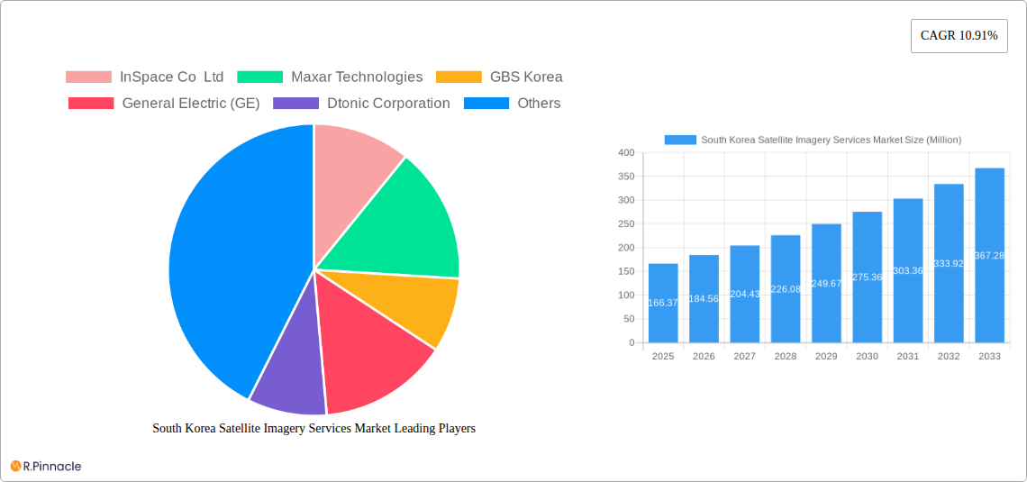
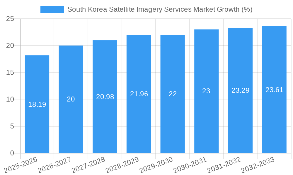
The South Korea satellite imagery services market, valued at $166.37 million in 2025, is projected to experience robust growth, exhibiting a Compound Annual Growth Rate (CAGR) of 10.91% from 2025 to 2033. This expansion is driven by several key factors. The increasing adoption of geospatial technologies across diverse sectors, including government initiatives for improved infrastructure planning and disaster management, fuels market demand. Furthermore, the burgeoning construction, transportation, and agricultural sectors are leveraging satellite imagery for precise surveying, route optimization, and precision farming, respectively. The South Korean government's focus on technological advancements and national security also contributes to the market's growth. Specific applications like surveillance and security, conservation research, and intelligence gathering are experiencing significant traction, creating lucrative opportunities for market players. Competition within the market is intense, with both international and domestic companies vying for market share. The presence of established players like Maxar Technologies and ESRI alongside emerging innovative companies indicates a dynamic and competitive landscape.
The market segmentation reveals significant opportunities across various applications and end-users. The Geospatial Data Acquisition and Mapping segment is likely the largest, followed by Natural Resource Management and Surveillance and Security, owing to their critical role in infrastructure development and national security. The Government sector dominates the end-user segment, due to its significant investments in infrastructure and defense, but the Construction, Transportation and Logistics sectors are also exhibiting high growth potential. While challenges such as data privacy concerns and the high initial investment costs for satellite imagery technology exist, the overall market outlook remains positive, with a continued upward trajectory projected for the forecast period. The consistent advancements in satellite technology, providing higher resolution and more frequent data acquisitions, further propel market growth.
South Korea Satellite Imagery Services Market Report: 2019-2033
This comprehensive report provides an in-depth analysis of the South Korea Satellite Imagery Services market, offering valuable insights for industry professionals, investors, and strategic decision-makers. The study period covers 2019-2033, with a base year of 2025 and a forecast period of 2025-2033. The report leverages extensive research to deliver actionable intelligence on market size, growth drivers, challenges, and emerging opportunities. Expect detailed segmentation by application and end-user, competitive landscape analysis, and key industry developments.
South Korea Satellite Imagery Services Market Structure & Innovation Trends
This section analyzes the South Korea satellite imagery services market's competitive landscape, innovation drivers, and regulatory environment. The market exhibits a moderately concentrated structure with key players like InSpace Co Ltd, Maxar Technologies, GBS Korea, and Dabeeo Inc holding significant market share. However, the emergence of smaller, specialized firms is increasing competition. The market share distribution among the top 5 players in 2025 is estimated at xx%.
Innovation is driven by advancements in satellite technology, AI-powered image processing, and increasing demand for high-resolution imagery across various sectors. Regulatory frameworks, particularly concerning data privacy and national security, significantly influence market operations. The market also experiences substitution pressure from alternative technologies like drone imagery and LiDAR. Mergers and acquisitions (M&A) activity is moderate, with deal values in 2024 estimated at xx Million. Recent examples include Dabeeo's partnership with Maxar Technologies in November 2022, expanding its imaging services and access to Maxar’s data. The end-user demographics are diverse, spanning government agencies, commercial entities, and research institutions.
- Market Concentration: Moderately concentrated, with top 5 players holding xx% market share in 2025.
- Innovation Drivers: Advancements in satellite technology, AI-powered image processing.
- Regulatory Framework: Significant influence on data privacy and national security.
- Product Substitutes: Drone imagery, LiDAR.
- M&A Activity: Moderate, with 2024 deal values estimated at xx Million.
South Korea Satellite Imagery Services Market Dynamics & Trends
The South Korea satellite imagery services market is experiencing robust growth, driven by increasing government investment in infrastructure development, rising demand for precise geospatial data across diverse sectors, and technological advancements improving image resolution and processing capabilities. The market is projected to exhibit a CAGR of xx% during the forecast period (2025-2033). Market penetration of satellite imagery services in key sectors like construction and transportation is increasing, driven by the need for improved project planning and management. Technological disruptions, particularly the integration of AI and machine learning in image analysis, are transforming the industry and creating new opportunities for value creation. Consumer preferences are shifting towards higher-resolution, real-time data, and customized solutions. The competitive dynamics are marked by intense competition, with established players focusing on strategic partnerships and technological innovation to maintain their market position.
Dominant Regions & Segments in South Korea Satellite Imagery Services Market
The South Korea satellite imagery services market is geographically concentrated, with the majority of activity centered in urban and technologically advanced regions.
By Application:
- Geospatial Data Acquisition and Mapping: This segment dominates due to the high demand for precise mapping data in urban planning, infrastructure development, and resource management. Key drivers include government initiatives promoting smart city development and the increasing use of GIS technologies.
- Surveillance and Security: This segment exhibits significant growth driven by the nation's focus on border security and national defense.
- Other applications: Natural Resource Management, Conservation and Research, Disaster Management, Intelligence are expected to show steady growth.
By End-User:
- Government: The government sector is the largest end-user, driven by substantial investments in national infrastructure projects, security initiatives, and environmental monitoring programs. Government policies and investments play a crucial role in market expansion.
- Construction: The construction sector’s demand for accurate mapping and site planning is a key driver, fueling market expansion.
- Military and Defense: This sector relies on high-quality satellite imagery for strategic planning, operational efficiency, and intelligence gathering. This creates high demand for specific capabilities and data.
- Other end-users: Transportation and Logistics, Forestry and Agriculture exhibit moderate growth.
South Korea Satellite Imagery Services Market Product Innovations
Recent product innovations focus on enhancing image resolution, improving data processing speed and accuracy through AI, and providing real-time data delivery. The integration of cloud computing and SaaS models is improving accessibility and affordability, driving market expansion. New applications include 3D modeling and virtual reality integration, adding value to the data offered. These innovations cater to growing demand for accurate, accessible, and readily usable data across diverse applications.
Report Scope & Segmentation Analysis
This report segments the South Korea satellite imagery services market by application (Geospatial Data Acquisition and Mapping, Natural Resource Management, Surveillance and Security, Conservation and Research, Disaster Management, Intelligence) and end-user (Government, Construction, Transportation and Logistics, Military and Defense, Forestry and Agriculture, Others). Each segment's growth projections, market size (in Million), and competitive dynamics are analyzed in detail. The market is expected to reach xx Million by 2033.
Key Drivers of South Korea Satellite Imagery Services Market Growth
Key growth drivers include increased government spending on infrastructure, rising demand for precise geospatial data in various sectors, technological advancements in satellite imagery and AI-powered image processing, and the growing adoption of cloud-based solutions. Specific examples include smart city initiatives and investments in national defense and security. The increasing importance of environmental monitoring and disaster management further fuels market expansion.
Challenges in the South Korea Satellite Imagery Services Market Sector
Challenges include the high cost of satellite imagery acquisition and processing, data security concerns, regulatory hurdles around data usage and privacy, and competition from alternative geospatial data sources. These factors can impede market growth and profitability. Supply chain disruptions may affect access to vital components and services, negatively impacting the market.
Emerging Opportunities in South Korea Satellite Imagery Services Market
Emerging opportunities lie in the integration of AI and machine learning for enhanced image analysis, the development of new applications in sectors like precision agriculture and autonomous vehicles, and the expansion into niche markets. The growth of the metaverse and the demand for high-resolution 3D mapping are also creating new opportunities.
Leading Players in the South Korea Satellite Imagery Services Market Market
- InSpace Co Ltd
- Maxar Technologies
- GBS Korea
- General Electric (GE)
- Dtonic Corporation
- ESRI Inc
- L3Harris Corporation Inc
- Soletop
- Bentley Systems Inc
- Dabeeo Inc
Key Developments in South Korea Satellite Imagery Services Market Industry
- November 2022: Dabeeo partnered with Maxar Technologies, expanding its imaging services and access to Maxar's data. This significantly boosted Dabeeo's market competitiveness.
- August 2022: Yahaha launched an AI mirror world project using Dabeeo's geospatial data and AI technology for 3D map creation. This showcases the potential of AI integration in the industry.
Future Outlook for South Korea Satellite Imagery Services Market Market
The South Korea satellite imagery services market is poised for continued growth, driven by technological advancements, increasing government investments, and expanding applications across diverse sectors. Strategic partnerships, innovation in AI-powered image analysis, and the development of new, specialized applications will shape future market dynamics and create significant opportunities for growth. The market is expected to witness substantial expansion in the coming years, driven by increasing demand for high-resolution, real-time geospatial data.
South Korea Satellite Imagery Services Market Segmentation
-
1. Application
- 1.1. Geospatial Data Acquisition and Mapping
- 1.2. Natural Resource Management
- 1.3. Surveillance and Security
- 1.4. Conservation and Research
- 1.5. Disaster Management
- 1.6. Intelligence
-
2. End-User
- 2.1. Government
- 2.2. Construction
- 2.3. Transportation and Logistics
- 2.4. Military and Defense
- 2.5. Forestry and Agriculture
- 2.6. Others
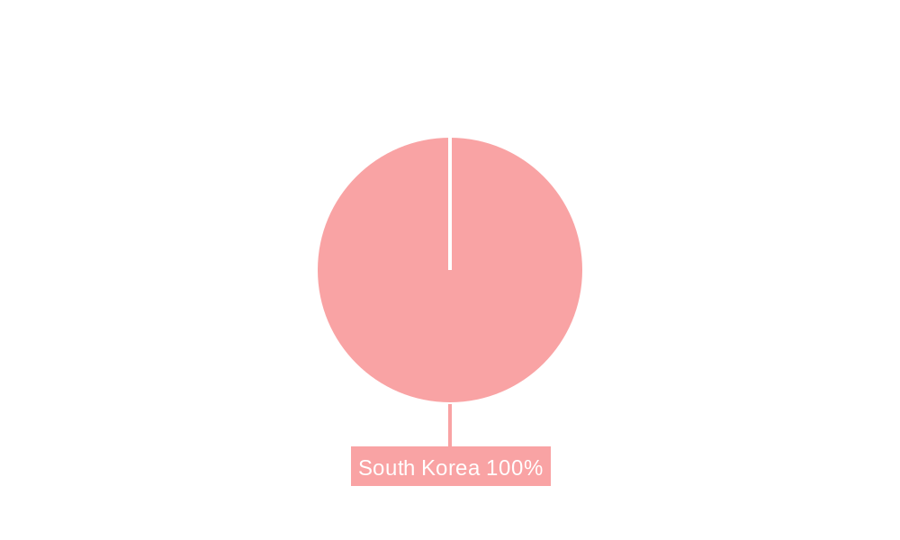
South Korea Satellite Imagery Services Market Segmentation By Geography
- 1. South Korea
South Korea Satellite Imagery Services Market REPORT HIGHLIGHTS
| Aspects | Details |
|---|---|
| Study Period | 2019-2033 |
| Base Year | 2024 |
| Estimated Year | 2025 |
| Forecast Period | 2025-2033 |
| Historical Period | 2019-2024 |
| Growth Rate | CAGR of 10.91% from 2019-2033 |
| Segmentation |
|
Table of Contents
- 1. Introduction
- 1.1. Research Scope
- 1.2. Market Segmentation
- 1.3. Research Methodology
- 1.4. Definitions and Assumptions
- 2. Executive Summary
- 2.1. Introduction
- 3. Market Dynamics
- 3.1. Introduction
- 3.2. Market Drivers
- 3.2.1. Growing requirement of Security System in South Korea; Rising Smart City Initiatives
- 3.3. Market Restrains
- 3.3.1. Budget Constraints and Technological Limitations
- 3.4. Market Trends
- 3.4.1. Growing Use of Satellite Imagery Services in Military and Defense Sector
- 4. Market Factor Analysis
- 4.1. Porters Five Forces
- 4.2. Supply/Value Chain
- 4.3. PESTEL analysis
- 4.4. Market Entropy
- 4.5. Patent/Trademark Analysis
- 5. South Korea Satellite Imagery Services Market Analysis, Insights and Forecast, 2019-2031
- 5.1. Market Analysis, Insights and Forecast - by Application
- 5.1.1. Geospatial Data Acquisition and Mapping
- 5.1.2. Natural Resource Management
- 5.1.3. Surveillance and Security
- 5.1.4. Conservation and Research
- 5.1.5. Disaster Management
- 5.1.6. Intelligence
- 5.2. Market Analysis, Insights and Forecast - by End-User
- 5.2.1. Government
- 5.2.2. Construction
- 5.2.3. Transportation and Logistics
- 5.2.4. Military and Defense
- 5.2.5. Forestry and Agriculture
- 5.2.6. Others
- 5.3. Market Analysis, Insights and Forecast - by Region
- 5.3.1. South Korea
- 5.1. Market Analysis, Insights and Forecast - by Application
- 6. Competitive Analysis
- 6.1. Market Share Analysis 2024
- 6.2. Company Profiles
- 6.2.1 InSpace Co Ltd
- 6.2.1.1. Overview
- 6.2.1.2. Products
- 6.2.1.3. SWOT Analysis
- 6.2.1.4. Recent Developments
- 6.2.1.5. Financials (Based on Availability)
- 6.2.2 Maxar Technologies
- 6.2.2.1. Overview
- 6.2.2.2. Products
- 6.2.2.3. SWOT Analysis
- 6.2.2.4. Recent Developments
- 6.2.2.5. Financials (Based on Availability)
- 6.2.3 GBS Korea
- 6.2.3.1. Overview
- 6.2.3.2. Products
- 6.2.3.3. SWOT Analysis
- 6.2.3.4. Recent Developments
- 6.2.3.5. Financials (Based on Availability)
- 6.2.4 General Electric (GE)
- 6.2.4.1. Overview
- 6.2.4.2. Products
- 6.2.4.3. SWOT Analysis
- 6.2.4.4. Recent Developments
- 6.2.4.5. Financials (Based on Availability)
- 6.2.5 Dtonic Corporation
- 6.2.5.1. Overview
- 6.2.5.2. Products
- 6.2.5.3. SWOT Analysis
- 6.2.5.4. Recent Developments
- 6.2.5.5. Financials (Based on Availability)
- 6.2.6 ESRI Inc
- 6.2.6.1. Overview
- 6.2.6.2. Products
- 6.2.6.3. SWOT Analysis
- 6.2.6.4. Recent Developments
- 6.2.6.5. Financials (Based on Availability)
- 6.2.7 L3Harris Corporation Inc
- 6.2.7.1. Overview
- 6.2.7.2. Products
- 6.2.7.3. SWOT Analysis
- 6.2.7.4. Recent Developments
- 6.2.7.5. Financials (Based on Availability)
- 6.2.8 Soletop
- 6.2.8.1. Overview
- 6.2.8.2. Products
- 6.2.8.3. SWOT Analysis
- 6.2.8.4. Recent Developments
- 6.2.8.5. Financials (Based on Availability)
- 6.2.9 Bentley Systems Inc
- 6.2.9.1. Overview
- 6.2.9.2. Products
- 6.2.9.3. SWOT Analysis
- 6.2.9.4. Recent Developments
- 6.2.9.5. Financials (Based on Availability)
- 6.2.10 Dabeeo Inc
- 6.2.10.1. Overview
- 6.2.10.2. Products
- 6.2.10.3. SWOT Analysis
- 6.2.10.4. Recent Developments
- 6.2.10.5. Financials (Based on Availability)
- 6.2.1 InSpace Co Ltd
List of Figures
- Figure 1: South Korea Satellite Imagery Services Market Revenue Breakdown (Million, %) by Product 2024 & 2032
- Figure 2: South Korea Satellite Imagery Services Market Share (%) by Company 2024
List of Tables
- Table 1: South Korea Satellite Imagery Services Market Revenue Million Forecast, by Region 2019 & 2032
- Table 2: South Korea Satellite Imagery Services Market Revenue Million Forecast, by Application 2019 & 2032
- Table 3: South Korea Satellite Imagery Services Market Revenue Million Forecast, by End-User 2019 & 2032
- Table 4: South Korea Satellite Imagery Services Market Revenue Million Forecast, by Region 2019 & 2032
- Table 5: South Korea Satellite Imagery Services Market Revenue Million Forecast, by Country 2019 & 2032
- Table 6: South Korea Satellite Imagery Services Market Revenue Million Forecast, by Application 2019 & 2032
- Table 7: South Korea Satellite Imagery Services Market Revenue Million Forecast, by End-User 2019 & 2032
- Table 8: South Korea Satellite Imagery Services Market Revenue Million Forecast, by Country 2019 & 2032
Frequently Asked Questions
1. What is the projected Compound Annual Growth Rate (CAGR) of the South Korea Satellite Imagery Services Market?
The projected CAGR is approximately 10.91%.
2. Which companies are prominent players in the South Korea Satellite Imagery Services Market?
Key companies in the market include InSpace Co Ltd, Maxar Technologies, GBS Korea, General Electric (GE), Dtonic Corporation, ESRI Inc, L3Harris Corporation Inc , Soletop, Bentley Systems Inc, Dabeeo Inc.
3. What are the main segments of the South Korea Satellite Imagery Services Market?
The market segments include Application, End-User.
4. Can you provide details about the market size?
The market size is estimated to be USD 166.37 Million as of 2022.
5. What are some drivers contributing to market growth?
Growing requirement of Security System in South Korea; Rising Smart City Initiatives.
6. What are the notable trends driving market growth?
Growing Use of Satellite Imagery Services in Military and Defense Sector.
7. Are there any restraints impacting market growth?
Budget Constraints and Technological Limitations.
8. Can you provide examples of recent developments in the market?
November 2022 - Dabeeo announced that the company is partnering with Maxar Technology. Through this partnership, Dabeeo is expanding its imaging services. Also, Dabeeo will cooperate with Maxar in various areas, including selling Maxar's satellite images, and will allow Dabeeo to provide more flexible technical collaboration and satellite image data.
9. What pricing options are available for accessing the report?
Pricing options include single-user, multi-user, and enterprise licenses priced at USD 3800, USD 4500, and USD 5800 respectively.
10. Is the market size provided in terms of value or volume?
The market size is provided in terms of value, measured in Million.
11. Are there any specific market keywords associated with the report?
Yes, the market keyword associated with the report is "South Korea Satellite Imagery Services Market," which aids in identifying and referencing the specific market segment covered.
12. How do I determine which pricing option suits my needs best?
The pricing options vary based on user requirements and access needs. Individual users may opt for single-user licenses, while businesses requiring broader access may choose multi-user or enterprise licenses for cost-effective access to the report.
13. Are there any additional resources or data provided in the South Korea Satellite Imagery Services Market report?
While the report offers comprehensive insights, it's advisable to review the specific contents or supplementary materials provided to ascertain if additional resources or data are available.
14. How can I stay updated on further developments or reports in the South Korea Satellite Imagery Services Market?
To stay informed about further developments, trends, and reports in the South Korea Satellite Imagery Services Market, consider subscribing to industry newsletters, following relevant companies and organizations, or regularly checking reputable industry news sources and publications.
Methodology
Step 1 - Identification of Relevant Samples Size from Population Database


Step 2 - Approaches for Defining Global Market Size (Value, Volume* & Price*)

Note*: In applicable scenarios
Step 3 - Data Sources
Primary Research
- Web Analytics
- Survey Reports
- Research Institute
- Latest Research Reports
- Opinion Leaders
Secondary Research
- Annual Reports
- White Paper
- Latest Press Release
- Industry Association
- Paid Database
- Investor Presentations

Step 4 - Data Triangulation
Involves using different sources of information in order to increase the validity of a study
These sources are likely to be stakeholders in a program - participants, other researchers, program staff, other community members, and so on.
Then we put all data in single framework & apply various statistical tools to find out the dynamic on the market.
During the analysis stage, feedback from the stakeholder groups would be compared to determine areas of agreement as well as areas of divergence


